

Vous vous intéressez à l’Urbanisme et l’Aménagement du Territoire en Région Wallonne ? Cet article a pour objectif de vous aider à comprendre l’Aménagement du Territoire en Wallonie ainsi que de vous donner les ressources et acronymes essentiels pour étudier la faisabilité d’un projet.
Vous trouverez un schéma récapitulatif à la fin de cet article.
L’aménagement du territoire et l’urbanisme sont deux concepts liés, mais distincts dans leur portée et leurs objectifs :
- L’aménagement du territoire concerne la planification et la gestion d’un territoire dans son ensemble, visant à favoriser un développement équilibré et durable en organisant l’utilisation des ressources naturelles, économiques et sociales. Il aborde des questions plus larges telles que les transports, l’environnement, les équipements publics et la préservation des espaces naturels.
- L’urbanisme se concentre sur l’organisation et la gestion des espaces urbains, qu’ils soient déjà urbanisés ou destinés à l’être. Il étudie l’implantation des bâtiments, l’organisation des quartiers, des espaces publics et des infrastructures urbaines, dans le but de créer des environnements urbains fonctionnels, esthétiques et adaptés aux besoins des habitants. Il prend en compte des éléments tels que la densité de population, la mobilité, l’architecture, l’accessibilité et l’esthétique urbaine.
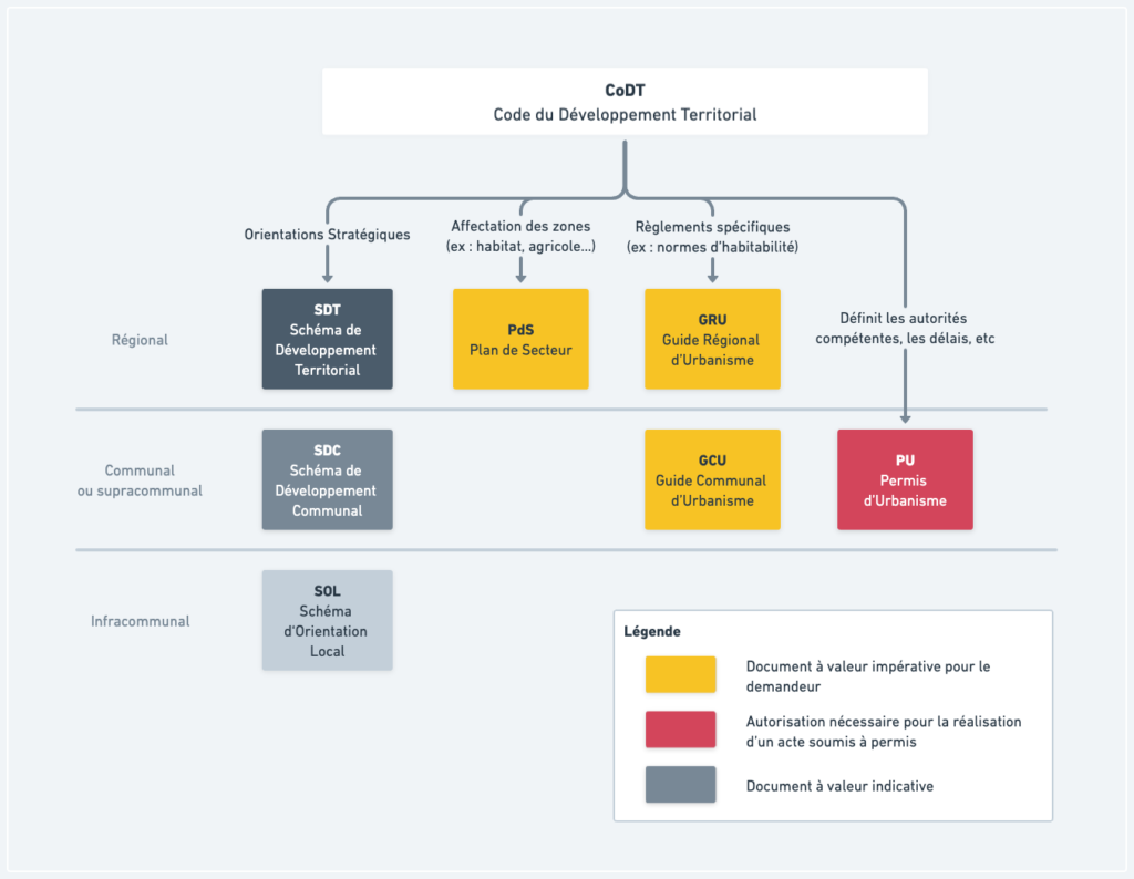
L’Urbanisme et l’Aménagement du Territoire est une compétence Régionale. À ce titre, chaque région dispose de sa propre base juridique, un code, (CoDT, CoBAT, VCRO) définissant l’organisation de cette compétence et ces modalités. Ces textes précisent notamment les éléments suivants :
- les actes soumis à permis (exemple : doit-on demander un permis pour construire une piscine ?)
- les autorités compétentes (exemple : quelle autorité se prononcera pour tel type d’acte, qui élabore quel plan, etc.)
- les voies de recours
- les outils de planification : ce sont tous les outils qui permettent d’établir les stratégies et de définir les règles d’aménagement et d’urbanisme.
Cet article s’intéressera particulièrement aux outils de planifications en Wallonie.
La base juridique : le CoDT
La base juridique de l’urbanisme en Wallonie est le Code du Développement Territorial (CoDT) :
“le territoire de la Wallonie est un patrimoine commun de ses habitants.
L’objectif du Code du Développement territorial, ci-après « le Code », est d’assurer un
développement durable et attractif du territoire.”
Ce document a pour vocation d’établir des règles générales comme les délais auxquels les autorités de délivrance de permis sont soumises, les travaux qui sont ou non soumis à permis, etc. A contrario, le CoDT ne définit par exemple pas la hauteur maximale admissible pour un bâtiment, ni les zones constructibles.
Cette base légale définit également une liste d’outils d’aménagement du territoire et de l’urbanisme que nous allons voir juste après. Parmi eux, nous retrouvons les schémas, les plans et les guides d’urbanisme.
Les schémas
Les schémas sont des outils de planification et de gestion de l’aménagement du territoire. Ils visent à organiser et orienter le développement territorial de manière cohérente et durable en tenant compte des enjeux économiques, sociaux, environnementaux et spatiaux à long terme.
Ces schémas sont élaborés à 4 échelles :
| Nom du Schéma | Abrégé | Échelle |
| Schéma de Développement Territorial | SDT | Régionale |
| Schéma de Développement Pluricommunal | SD(P)C | Supracommunal |
| Schéma de Développement Communal | SDC | Communal |
| Schéma d’Orientation Local | SOL | Infracommunal |
Le Schéma de Développement Territorial (SDT)
Un schéma de développement territorial (SDT) est une stratégie régionale qui définit les objectifs de développement et d’aménagement du territoire pour l’ensemble de la Région Wallonne. Il est élaboré à partir d’une analyse contextuelle approfondie, prenant en compte les enjeux territoriaux majeurs, les perspectives et les besoins sociaux, économiques, démographiques, énergétiques, patrimoniaux, environnementaux et de mobilité, ainsi que les potentialités et les contraintes du territoire.
C’est notamment dans le SDT que son abordées les notions d’étalement urbain et d’artificialisation.

Le Schéma de Développement Communal ou Pluricommunal (SDC ou SDPC)
Le Schéma de Développement Communal est un outil de planification utilisé par une commune pour définir sa stratégie de développement territorial. Il peut également être élaboré conjointement par plusieurs communes, auquel cas il est appelé « Schéma de Développement Pluricommunal ».
Ce document identifie les principaux défis, objectifs et actions à entreprendre afin de favoriser le développement économique, social, environnemental et urbain de la commune. Il prend en compte les caractéristiques spécifiques de la commune et propose des mesures concrètes pour améliorer la qualité de vie des résidents, promouvoir l’utilisation rationnelle des ressources, renforcer les infrastructures et les services, et gérer efficacement les questions de mobilité.
Le Schéma de Développement Communal constitue ainsi une feuille de route pour guider les décisions d’aménagement et d’urbanisme de la commune dans le but d’atteindre un développement harmonieux et durable. Cependant, ce document n’est pas directement utile pour le porteur de projet. Il est davantage utilisé comme document interne dans les administrations communales.
Le Schéma d’Orientation Local (SOL)
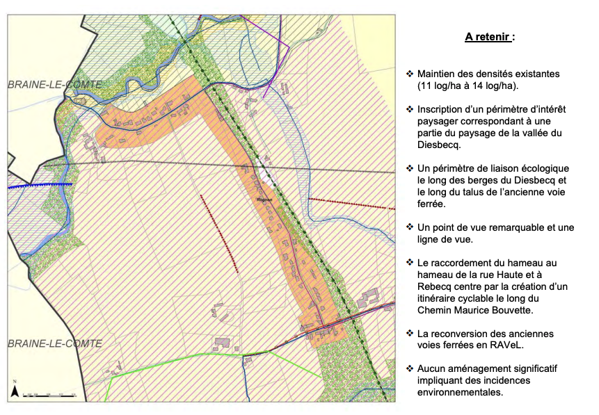
Le Schéma d’Orientation Local (SOL) est un outil de planification utilisé pour déterminer les objectifs d’aménagement du territoire et d’urbanisme pour une partie spécifique du territoire communal.
Basé sur une analyse contextuelle incluant les principaux enjeux, les potentialités et les contraintes du territoire, le SOL comprend des objectifs d’aménagement du territoire et d’urbanisme, ainsi qu’une carte d’orientation détaillée.

Cette carte comprend des éléments tels que le réseau viaire, les infrastructures techniques, les espaces publics, les espaces verts, les zones d’affectation du territoire, la structure écologique, et éventuellement, les lignes de force du paysage. Le SOL peut également fournir des indications sur l’implantation, la hauteur des constructions et des ouvrages, les voiries, les espaces publics et l’intégration des équipements techniques. De plus, il peut identifier d’autres SOL et le guide communal à élaborer, réviser ou abroger. Le SOL constitue ainsi un cadre directeur pour guider l’aménagement et l’urbanisme dans une zone spécifique, en favorisant une utilisation cohérente et durable de l’espace.
Le plan d’affectation
Le Plan de Secteur
Utilité du plan de secteur
Le plan de secteur est un document qui fixe l’aménagement du territoire en Région Wallonne. Il définit les différents secteurs d’aménagement qui feront l’objet d’un plan. Certaines infrastructures spécifiques, telles que les infrastructures ferroviaires, aéroportuaires et les ports autonomes, ne sont pas affectées par ce plan.
Ce plan d’affectation s’inspire du schéma de développement du territoire, mais peut s’en écarter sous certaines conditions. Il vise à protéger, gérer et aménager les paysages, tant bâtis que non bâtis.
Il s’applique à différents schémas de développement, permis et certificats d’urbanisme. Des prescriptions supplémentaires peuvent également être ajoutées, telles que la précision ou la spécialisation de l’affectation des zones, le phasage de leur occupation, la réversibilité des affectations ou l’obligation d’élaborer un schéma d’orientation local préalablement à leur mise en œuvre.
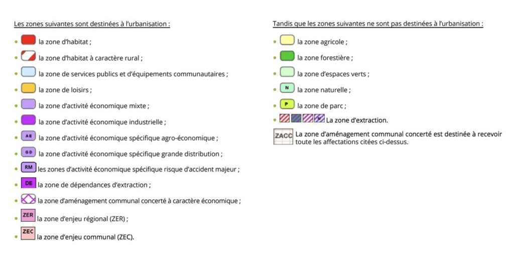
Les affectations du plan de secteur peuvent être divisées en deux groupes :
- Les zones destinées à l’urbanisation : celles-ci comprennent des zones d’habitat, des zones de services publics, des zones de loisirs, des zones d’activité économique, des zones d’enjeu régional et des zones d’enjeu communal.
- Les zones non destinées à l’urbanisation : celles-ci comprennent des zones agricoles, forestières, d’espaces verts, naturelles, de parc et d’extraction.
Comment lire le plan de secteur et où le retrouver ?
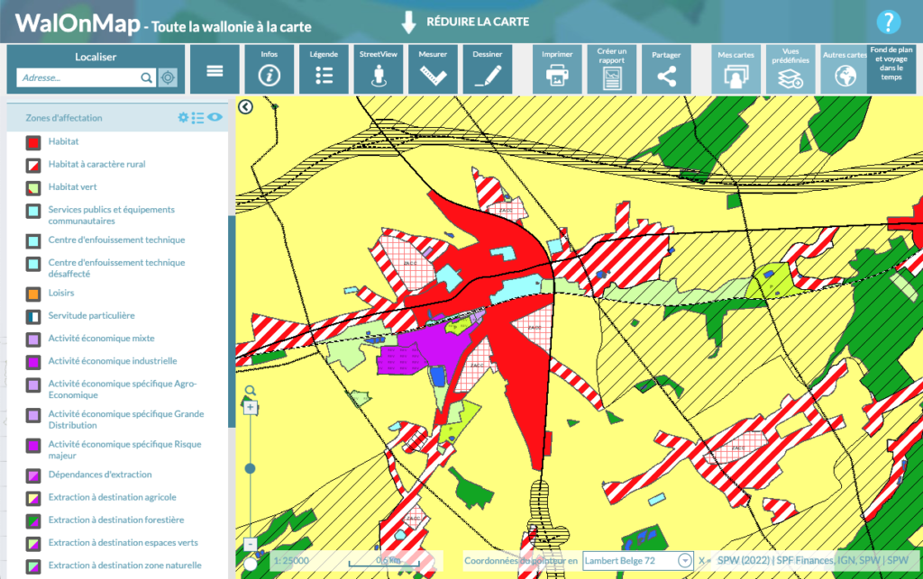
Vous pouvez retrouver le Plan de Secteur sur WalOnMap
WalOnMap, qu’est-ce que c’est ? WalOnMap est une application développée par le Service public de Wallonie qui permet aux utilisateurs d’afficher sur une carte du territoire wallon des données géographiques publiques, tout en offrant des fonctionnalités de zoom, de localisation, de choix de fond de plan et d’accès à une variété d’informations géographiques dans différents domaines.
L’outil permet ainsi d’identifier une parcelle sur base d’une adresse, d’en connaître l’affectation (zone agricole, zone d’habitat, etc.), les prescriptions urbanistiques particulières qui pourraient s’appliquer et d’étudier les éventuels risques associés (inondations, éboulement, etc.)
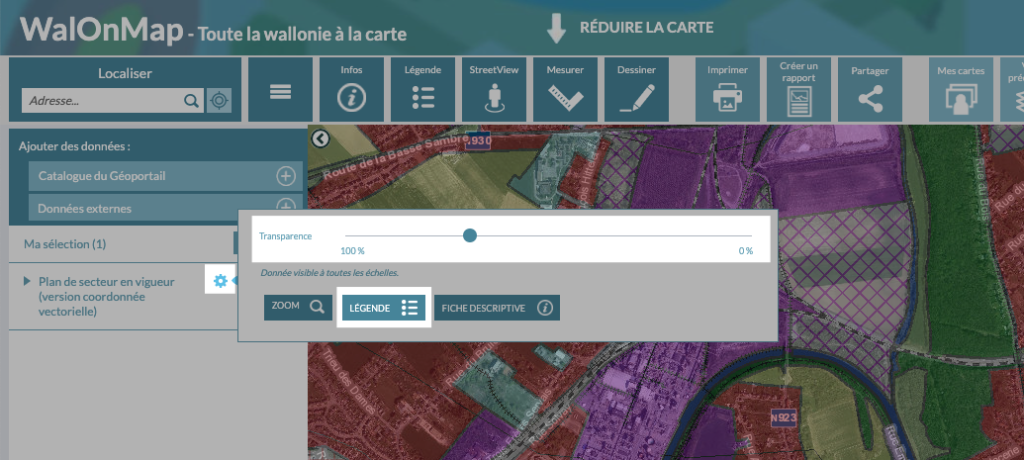
Astuce : vous pouvez modifier l’opacité du calque afin de mieux percevoir les limites du plan de secteur. Cela vous permettra, sur base de la vue satellite et de votre connaissance du lieu, de mieux percevoir les limites du plan de secteur par rapport au monde réel. Pour modifier l’opacité du calque :
– Cliquez sur la roue dentée à gauche, au niveau de votre sélection
– Changer le curseur à environ 50%, cela rendra le plan de secteur partiellement transparent et laissera apparaître la vue satellite juste en dessous.
– Vous pouvez également afficher la légende en cliquant sur le bouton “Légende” dans le même menu. (lien vers le document complet des légendes)
Les règlements
Les règlements en matières d’urbanismes sont appelés “Guides” en Wallonie et sont disponibles sur le site de la DGO4. On y retrouve, entre autres, les documents suivants :
- Le Guide Régional d’Urbanisme (GRU)
- Les Guides Communaux d’Urbanisme (GCU)
Nous aborderons les principales sources d’informations utiles ci-dessous.
Le Guide Régional d’Urbanisme (GRU)
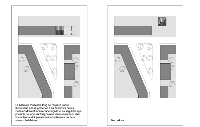
Le guide régional d’urbanisme donne des lignes directrices concernant l’harmonie du bâti ou les normes pour l’accessibilité pour les personnes à mobilités réduites.
Voici à titre d’exemple deux extraits du GRU :
Pignons, façades latérales et façades arrière.
Guide régional d’urbanisme – Coordination officieuse – 31 mai 2017
Les matériaux autorisés pour les murs, pignons, façades latérales et façades
arrières devront s’harmoniser avec ceux des façades à rue.
Les pentes :
Guide régional d’urbanisme – Coordination officieuse – 31 mai 2017
La pente transversale ou dévers est de 2 % maximum.
Lorsqu’une pente en long est nécessaire, elle est idéalement inférieure ou
égale à 5 centimètres par mètre pour une longueur maximale de 10 mètres.
En cas d’impossibilité technique d’utiliser des pentes inférieurs ou égales à
5 %, les pentes suivantes sont exceptionnellement tolérées […]
Le Guide Communal d’Urbanisme (GCU)
Édité à l’échelle communale, ce guide définit les prescriptions urbanistiques applicables et se veut être la mise en œuvre locale du Guide Régional d’Urbanisme. Il définit par exemple la morphologie du bâti, l’implantation du bâti, et les conditions de recul et d’alignement.
Vous retrouverez le plus souvent ce document sur le site des communes. Il est le document de référence permettant d’esquisser un projet immobilier.
Résumé
En Wallonie, c’est le Code du Développement Territorial qui régit l’Aménagement du Territoire et l’Urbanisme. Ce texte définit les règles générales telles que les actes soumis à permis, les délais de délivrances, les autorités compétentes ainsi que les outils de planification.
Parmi ces outils, les Schémas définissent les grandes orientations stratégiques, sur bases des enjeux du territoire concerné. Ces schémas se déclinent à l’échelle régionale, supracommunale, communale et infracommunale. Ils ne sont pas impératifs pour le demandeur, mais peuvent impacter la décision de la commune quant à l’octroi ou non du permis d’urbanisme.
Les Guides définissent des règles à respecter en matière d’urbanisme. Il s’agit par exemple des normes d’habitabilité (surface minimale, hauteur sous plafond, etc.) ou de construction (géométrie, distance à la voirie, alignement des façades, etc.). Il existe un Guide Régional qui s’applique pour toute la Wallonie ainsi que des Guides Communaux qui s’appliquent localement et précisent la mise en œuvre locale de certaines règles.
Finalement, c’est la commune qui est l’autorité compétente pour l’octroi d’un permis d’urbanisme. Pour ce faire, elle étudie le dossier en analysant la conformité du projet avec le Plan de Secteur, les normes régionales (GRU) et locales (GCU) ainsi que l’alignement vis-à-vis des orientations stratégiques (SDT, SDC, SOL).