
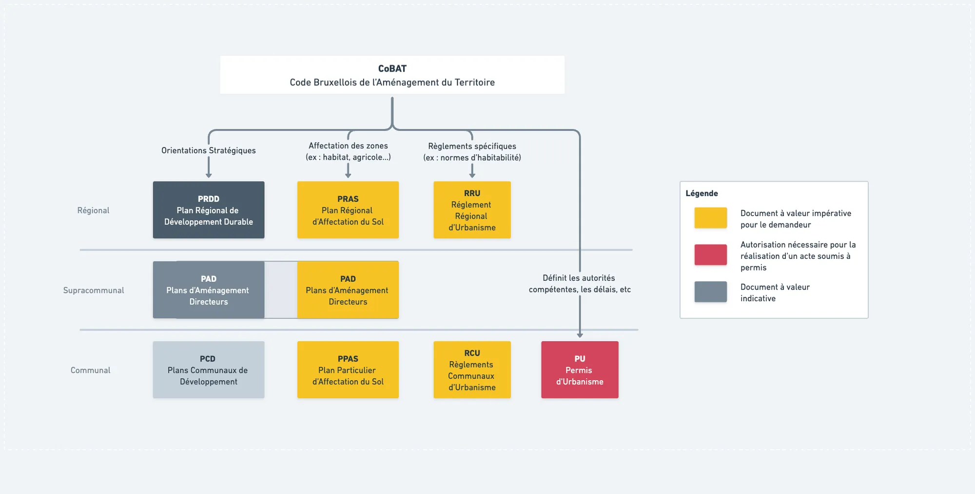
Interested in urban planning law in the Brussels-Capital Region? This article aims to help you understand Town Planning in Brussels, and give you the essential resources and acronyms to study the feasibility of a project.
In this article
- Introduction
- The legal basis: the CoBAT
- Strategic plans
- The Regional Development Plan (PRD)
- Municipal Development Plans (PCD)
- Regulatory plans
- The Regional Land Use Plan (PRAS)
- The 6 maps of the PRAS
- The literal prescriptions of the PRAS
- The Master Development Plan (PAD)
- The Specific Land Use Plan (PPAS)
- The Regional Land Use Plan (PRAS)
-
Regulations
- The Regional Urban Planning Regulation (RRU)
- The Municipal Urban Planning Regulation (RCU)
-
Summary
Introduction
Town planning and urbanism are two related but distinct concepts in their scope and objectives:
- Town planning (aménagement du territoire) concerns the planning and management of a territory as a whole, aiming to promote balanced and sustainable development by organising the use of natural, economic and social resources. It addresses broader questions such as transport, the environment, public facilities and the preservation of natural areas.
- Urbanism (urbanisme) focuses on the organisation and management of urban spaces, whether already built up or intended to be. It examines the siting of buildings, the organisation of neighbourhoods, public spaces and urban infrastructure, with the aim of creating urban environments that are functional, aesthetically pleasing and suited to residents’ needs. It takes into account elements such as population density, mobility, architecture, accessibility and urban aesthetics.
Urbanism and Town Planning is a Regional competence in Belgium. As such, each region has its own legal basis, a code (CoDT, CoBAT, VCRO) defining the organisation of this competence and its procedures. These texts notably specify:
- the acts subject to a permit (example: is a permit required to build a swimming pool?)
- the competent authorities (example: which authority rules on which type of act, who draws up which plan, etc.)
- the appeal procedures
- the planning tools: all the tools used to establish strategies and define planning and urbanism rules.
This article focuses specifically on the planning tools used in Belgium.
The legal basis: the CoBAT
The legal basis for urbanism in the Brussels-Capital Region is the Brussels Town Planning Code (Code Bruxellois de l’Aménagement du Territoire, CoBAT). As such, the CoBAT governs the main mechanisms of town planning in Brussels:
- Planning (strategic development plans, land use plans, etc.)
- Urban planning regulations (RRU, RCU)
- Permit applications (which works are subject to a permit or not, competent authorities, deadlines, appeal procedures, etc.)
- Heritage protection
- The right of pre-emption (a legal or contractual right granted to certain private or public parties to acquire a property in priority over any other person, when the owner expresses the intention to sell)
- Urban planning information (the planning context of a specific property, required for any real estate sale)
Strategic plans
Strategic plans are documents that define and represent the strategy to be followed to achieve specific objectives. These objectives are generally related to town planning. Strategic plans set out the broad directions to be followed and become the founding principles of territorial planning.
It is important to note that, in most cases, strategic plans have an indicative (non-binding) value. The main regional development plans in force in Brussels are discussed below.
The Regional Development Plan (PRD)
The Regional Development Plan (Plan Régional de Développement, PRD) sets the Region’s development objectives and priorities, based on economic, social, environmental and mobility needs.
In 2009, the PRD was supplemented with a second “D” for “durable” (sustainable), symbolising the Region’s determination to address the major challenges of the century in terms of environment and sustainable development.
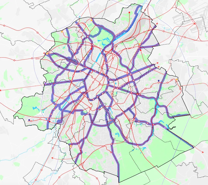 Map 6 of the PRDD-2018: structuring mobility networks
Municipal Development Plans (PCD)
Municipal Development Plans (Plans Communaux de Développement, PCD) cover the entire municipal territory and constitute comprehensive planning tools for the sustainable development of municipalities. They are aligned with the directions of the PRD and comply with the Regional Land Use Plan (PRAS), another regional development plan.
It is a comprehensive planning tool for the development of municipalities. It establishes the following:
- The general and specific objectives, as well as the development priorities, including town planning, needed to meet economic, social, cultural, mobility, accessibility and environmental needs;
- The cross-cutting and sectoral measures to be put in place to achieve the defined objectives, notably through a map-based representation of some of these measures;
- The identification of the municipality’s priority intervention zones;
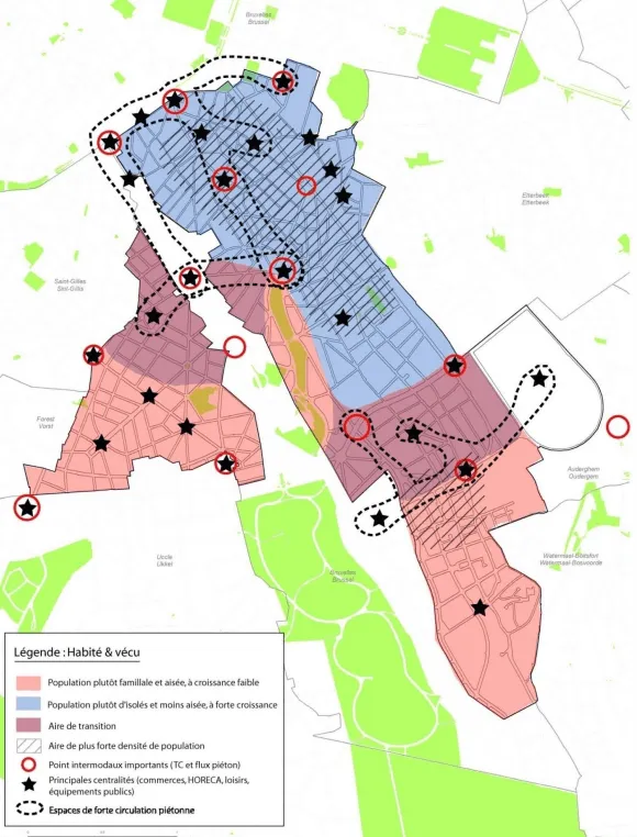 Excerpt from the PCD of the municipality of Ixelles
Regulatory plans
Unlike strategic plans, planning documents with regulatory value determine the functions that may be established in the various zones of Brussels.
The Regional Land Use Plan (PRAS)
The Regional Land Use Plan (Plan Régional d’Affectation du Sol, PRAS) follows the directions of the Regional Development Plan (PRD) and determines the land uses of the Brussels-Capital Region’s territory, as well as the rules that apply to them. The PRAS defines, for example, the priority use of a zone (housing, commerce, etc.). A zone is defined by one or more blocks of parcels. The smallest graphic unit of the PRAS is the urban block.
The PRAS is in fact a set of maps (plans) and literal prescriptions (texts).
The 6 maps of the PRAS
| Map title | Value | Description |
|---|---|---|
| Existing de facto situation | Indicative | Current situation of land uses as actually practised today. |
| Existing de jure situation | Indicative | Provisions relating to urban planning, heritage and the environment applicable to the zone. |
| Land use map | Regulatory | Equivalent of the Plan de Secteur in Wallonia, it defines the uses authorised by zone (housing, commerce, etc.). |
| Map of admissible office balances | Regulatory | Map indicating the balance of admissible office m² for assessing use conversions. |
| Road network map | Regulatory | Regulatory map indicating roads and motorways within the Brussels perimeter. |
| Public transport map | Regulatory | Regulatory map of the public transport network, including underground and surface lines. |
The 6 maps of the Regional Land Use Plan 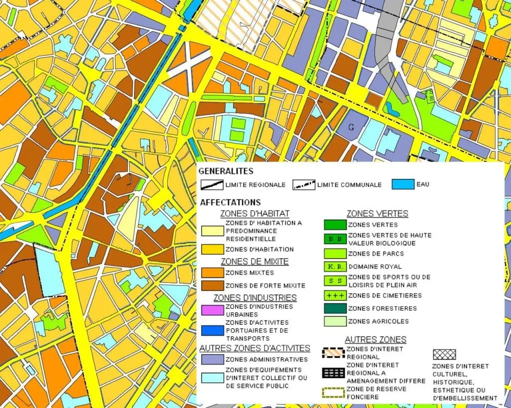 PRAS land use map PRAS land use map |
The literal prescriptions of the PRAS
There are different types of literal prescriptions depending on their geographic or thematic scope:
- General prescriptions applicable to all zones. Except where otherwise stated, the general prescriptions apply to all PRAS zones.
- Specific prescriptions relating to the various zones of the land use map (housing, commerce, facilities, green spaces, etc.).
- Specific prescriptions relating to roads and public transport.
- The programme for Regional Interest Areas (ZIR) and Regional Interest Areas with Deferred Development (ZIRAD).
Here is an example of specific prescriptions applicable to residential zones:
- Outside commercial hub frontages, the ground floors of buildings may be used for retail. The first floor may also be used for retail where local conditions allow, after the acts and works have undergone special publicity measures.
- The floor area used for retail may not exceed, per project and per building, 150 m².
- However, the retention of at least one dwelling in the building must be ensured.
PRAS: Specific prescriptions relating to residential zones
✅ It is important to note that zones are not always mutually exclusive. This means, for example, that a plot may be classified both as a Residential Zone AND as a Zone of Cultural, Historical, Aesthetic or Amenity Interest, one not excluding the other.
The Master Development Plan (PAD)
The Master Development Plan (Plan d’Aménagement Directeur, PAD) is distinctive in that it allows both the strategic and regulatory aspects of a development strategy to be defined at once. Like the PRAS, the PAD is drawn up at regional level but concerns a specific location.
All PADs are listed in the PAD dashboard. Examples include the following PADs: Bordet, Delta Herrmann-Debroux, Heysel, etc.
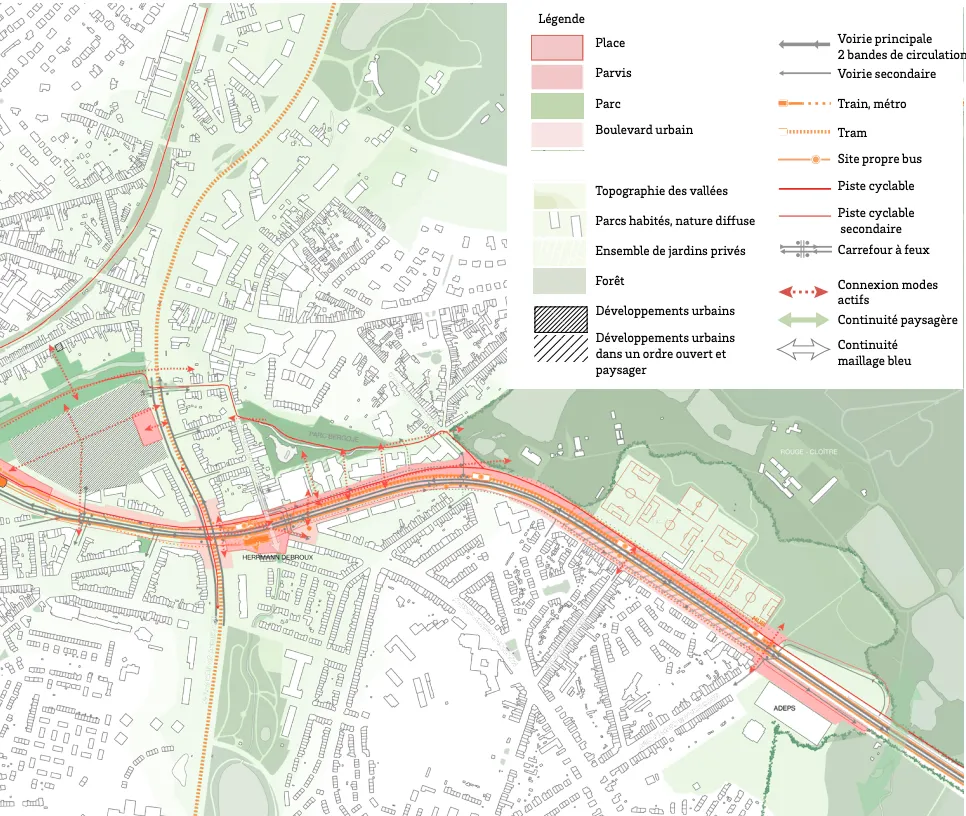 Excerpt from the “Delta Herrmann-Debroux” PAD
The Specific Land Use Plan (PPAS)
The Specific Land Use Plan (Plan Particulier d’Affectation du Sol, PPAS) serves to detail and complement the Regional Land Use Plan (PRAS). It complies with the directions set out in the Municipal Development Plan (PCD) and establishes the detailed land uses of the various zones. It regulates land use by delimiting buildable zones and green zones, together with the rules associated with them. It may also contain other provisions such as:
- Indications regarding the location, dimensions and aesthetic appearance of buildings and their surroundings.
- The layout and planning measures for roads and communication routes, as well as the regulations attached to them.
You can find these plans on the BruGIS platform: https://gis.urban.brussels/brugis/#/
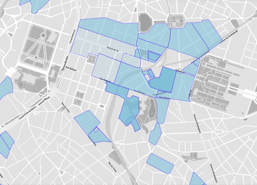
Regulations
The Regional Urban Planning Regulation (RRU)
The Regional Urban Planning Regulation (Règlement Régional d’Urbanisme, RRU) comprises 8 chapters (called “Titles”), which define very specific aspects of buildings and their surroundings:
| Title | Description |
|---|---|
| Title I | Characteristics of buildings and their surroundings |
| Title II | Housing habitability standards |
| Title III | Construction sites, title partially repealed – see the coordinated version of Title III currently in force |
| Title IV | Accessibility of buildings for people with reduced mobility |
| Title V | Thermal insulation of buildings, title fully repealed |
| Title VI | Advertising and signage |
| Title VII | Roads, their accesses and surroundings |
| Title VIII | Off-street parking standards |
| Structure of the Regional Urban Planning Regulation |
In Title I, for example, one finds the definitions of concepts such as building lines, party boundaries, etc. These concepts define the exterior visual characteristics of the building.
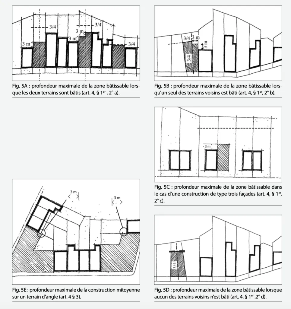 Excerpt from Title I of the RRU on the siting and massing of buildings on shared boundaries
Title II defines habitability standards, in terms of ceiling height and minimum living area.
 Excerpt from Title II of the RRU on the surface area standards applicable to new housing
The Municipal Urban Planning Regulation (RCU)
Municipal Urban Planning Regulations (Règlements Communaux d’Urbanisme, RCU) define additional rules on top of the RRU and may not contradict it. Depending on the municipality, these regulations may concern buildings, the placement of satellite dishes, pavements, and may apply to the entire municipality or only part of it.
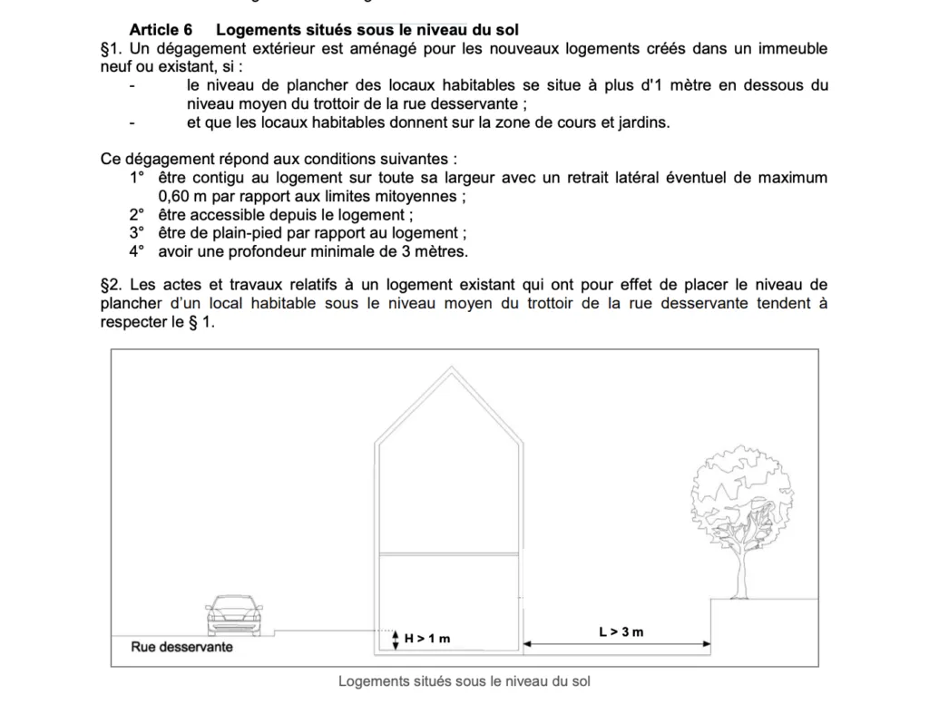 Excerpt from the RCU of the municipality of Anderlecht regarding dwellings located below ground level
Some municipalities make their RCU freely available on the urbanisme.irisnet website or on their own website, while for others, you need to visit the municipality in person to obtain the information.
Summary
In the Brussels-Capital Region, it is the Brussels Town Planning Code (CoBAT) that governs Urbanism and Town Planning. This code sets out the rules, deadlines, competent authorities and planning tools needed to implement a town planning policy.
Among these tools, Strategic Plans guide planning policy from the regional level down to the municipal level. These plans are not directly relevant to a permit applicant.
Regulatory Plans, on the other hand, are binding on the project developer. There are 3 of them:
- The PRAS: the Regional Land Use Plan defines the possible land uses at regional scale
- The PPAS: the Specific Land Use Plan is a municipal tool that defines planning rules at neighbourhood scale.
- The PAD: the Master Development Plan is the regional planning tool that allows both the strategic and regulatory aspects of an urban strategy to be defined in a single instrument. This plan applies only to certain specific zones.
In the Brussels-Capital Region, the issuing of town planning permits falls under the competence of the municipalities. In the event of an administrative appeal (following a refusal of authorisation), permits are issued by the Government of the Brussels-Capital Region.
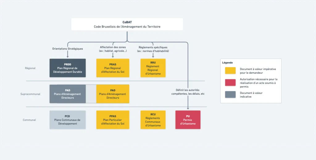 The Town Planning and Urbanism tools in the Brussels-Capital Region.