
Interested in Urban Planning and Spatial Planning in the Walloon Region? This article aims to help you understand Spatial Planning in Wallonia as well as give you the essential resources and acronyms to study the feasibility of a project.
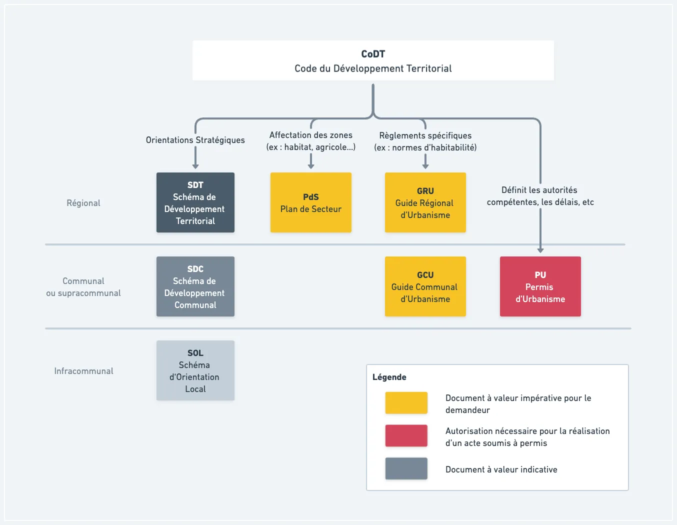
You will find a summary diagram at the end of this article.
Spatial planning and urban planning are two related but distinct concepts, differing in scope and objectives:
- Spatial planning concerns the planning and management of a territory as a whole, aiming to foster balanced and sustainable development by organizing the use of natural, economic and social resources. It addresses broader issues such as transport, the environment, public facilities and the preservation of natural areas.
- Urban planning focuses on the organization and management of urban spaces, whether already built up or intended to become so. It studies the siting of buildings, the organization of neighborhoods, public spaces and urban infrastructure, with the aim of creating functional, aesthetically pleasing urban environments suited to residents’ needs. It takes into account elements such as population density, mobility, architecture, accessibility and urban aesthetics.
Urban Planning and Spatial Planning is a regional competence in Belgium. As such, each region has its own legal basis, a code (CoDT in Wallonia, CoBAT in Brussels, VCRO in Flanders) defining the organization of this competence and its terms. These texts notably specify:
- which acts require a permit (example: do you need a permit to build a swimming pool?)
- the competent authorities (example: which authority rules on which type of act, who drafts which plan, etc.)
- the avenues of appeal
- the planning tools: these are all the tools used to establish strategies and define planning and urban development rules.
This article will focus specifically on the planning tools used in Wallonia.
- The legal basis: the CoDT
- The schemes
- The Territorial Development Scheme (SDT)
- The Municipal or Multi-Municipal Development Scheme (SDC or SDPC)
- The Local Orientation Scheme (SOL)
- The land-use plan
- The Sector Plan
- Purpose of the sector plan
- How to read the sector plan and where to find it
- The Sector Plan
- The regulations
- The Regional Urban Planning Guide (GRU)
- The Municipal Urban Planning Guide (GCU)
- Summary
The legal basis: the CoDT
The legal basis for urban planning in Wallonia is the Code du Développement Territorial (CoDT — Territorial Development Code):
“the territory of Wallonia is a shared heritage of its inhabitants. The purpose of the Territorial Development Code, hereinafter “the Code,” is to ensure sustainable and attractive development of the territory.“
This document is intended to establish general rules, such as the deadlines permit-issuing authorities must respect, and which works do or do not require a permit. Conversely, the CoDT does not, for example, define the maximum admissible height for a building, nor which zones are buildable.
This legal basis also defines a list of spatial and urban planning tools which we will look at next. Among these are schemes, plans and urban planning guides.
The schemes
Schemes are planning and management tools for spatial development. They aim to organize and steer territorial development in a coherent and sustainable way, taking into account long-term economic, social, environmental and spatial issues.
These schemes are drawn up at 4 scales:
| Scheme name | Abbreviation | Scale |
|---|---|---|
| Territorial Development Scheme | SDT | Regional |
| Multi-Municipal Development Scheme | SD(P)C | Supra-municipal |
| Municipal Development Scheme | SDC | Municipal |
| Local Orientation Scheme | SOL | Sub-municipal |
The Territorial Development Scheme (SDT)
A territorial development scheme (SDT) is a regional strategy that sets the development and planning objectives for the entire Walloon Region. It is drawn up based on an in-depth contextual analysis, taking into account the major territorial issues, social, economic, demographic, energy, heritage, environmental and mobility needs and outlooks, as well as the potential and constraints of the territory.
The SDT is notably where the concepts of urban sprawl and land artificialization are addressed.
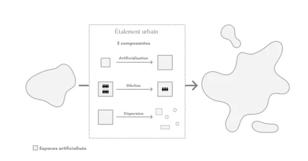 The concept of urban sprawl, as presented in the draft SDT of March 30, 2023
The Municipal or Multi-Municipal Development Scheme (SDC or SDPC)
The Municipal Development Scheme is a planning tool used by a municipality to define its territorial development strategy. It can also be jointly drawn up by several municipalities, in which case it is called a “Multi-Municipal Development Scheme.”
This document identifies the main challenges, objectives and actions to be undertaken in order to foster the economic, social, environmental and urban development of the municipality. It takes into account the municipality’s specific characteristics and proposes concrete measures to improve residents’ quality of life, promote the rational use of resources, strengthen infrastructure and services, and effectively manage mobility issues.
The Municipal Development Scheme thus serves as a roadmap to guide the municipality’s planning and urban development decisions with the aim of achieving harmonious and sustainable development. However, this document is not directly useful to a project developer. It is mainly used as an internal document within municipal administrations.
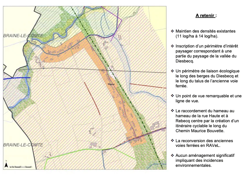 Excerpt from the Municipal Development Scheme of the municipality of Rebecq (Walloon Brabant)
The Local Orientation Scheme (SOL)
The Local Orientation Scheme (SOL) is a planning tool used to set spatial and urban planning objectives for a specific part of the municipal territory.
Based on a contextual analysis including the main issues, potential and constraints of the territory, the SOL includes spatial and urban planning objectives, as well as a detailed orientation map.
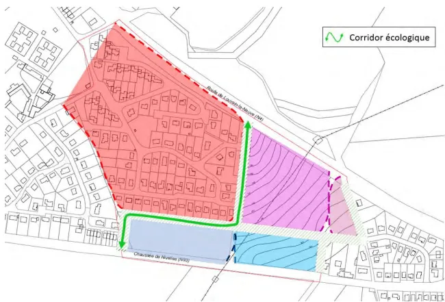 Excerpt from the SOL implementing the Suarlée ZACC zone
This map includes elements such as the road network, technical infrastructure, public spaces, green spaces, land-use zones, ecological structure and, where relevant, the landscape’s guiding lines. The SOL can also provide guidance on the siting and height of buildings and structures, roads, public spaces and the integration of technical facilities. It may also identify other SOLs and the municipal guide to be drawn up, revised or repealed. The SOL thus serves as a guiding framework for planning and development in a specific zone, promoting a coherent and sustainable use of space.
The land-use plan
The Sector Plan
Purpose of the sector plan
The sector plan is a document that establishes land-use planning in the Walloon Region. It defines the various planning sectors that will be subject to a plan. Certain specific infrastructures, such as rail infrastructure, airports and autonomous ports, are not affected by this plan.
This land-use plan is inspired by the territorial development scheme, but may depart from it under certain conditions. It aims to protect, manage and plan landscapes, both built and unbuilt.
It applies to various development schemes, permits and urban planning certificates. Additional requirements may also be added, such as further specifying the use of zones, phasing their occupation, the reversibility of land uses, or the obligation to draw up a local orientation scheme prior to implementation.
Sector plan land uses can be divided into two groups:
- Zones intended for urbanization: these include residential zones, public service zones, recreational zones, economic activity zones, regional priority zones and municipal priority zones.
- Zones not intended for urbanization: these include agricultural, forest, green space, natural, park and extraction zones.
How to read the sector plan and where to find it
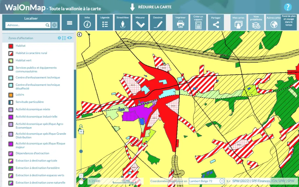
[You can find the Sector Plan on WalOnMap](https://geoportail.wallonie.be/walonmap#panier=\[{"serviceId":"7fe2f305-1302-4297-b67e-792f55acd834","visible“: true,“url”:“https://geoservices.wallonie.be/arcgis/rest/services/AMENAGEMENT_TERRITOIRE/PDS/MapServer","label":"Plan de secteur en vigueur (version coordonnée vectorielle)”,“type”:“AGS_DYNAMIC”}])
What is WalOnMap? WalOnMap is an application developed by the Public Service of Wallonia that allows users to display public geographic data on a map of Walloon territory, while offering zoom, location, basemap-selection features and access to a variety of geographic information across different fields.
The tool makes it possible to identify a parcel based on an address, find out its land use (agricultural zone, residential zone, etc.), any specific urban planning requirements that might apply, and study possible associated risks (flooding, landslides, etc.)
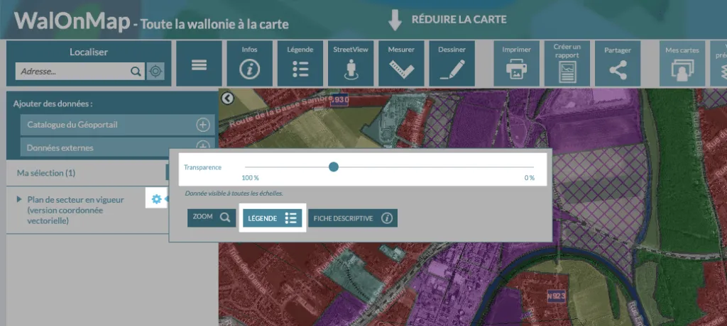
Tip: you can change the layer’s opacity to better see the sector plan’s boundaries. This lets you, using the satellite view and your knowledge of the location, better perceive the sector plan’s boundaries relative to the real world. To change the layer’s opacity: – Click the gear icon on the left, next to your selection – Move the slider to about 50%, which will make the sector plan partially transparent and reveal the satellite view underneath. – You can also display the legend by clicking the “Legend” button in the same menu. (link to the full legend document)
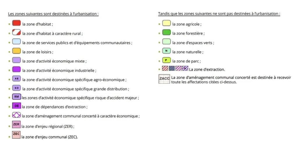 Legend of the main elements of the sector plan in Wallonia
The regulations
Urban planning regulations are called “Guides” in Wallonia and are available on the DGO4 website. These include, among others, the following documents:
- The Regional Urban Planning Guide (GRU)
- The Municipal Urban Planning Guides (GCU)
We will cover the main useful sources of information below.
The Regional Urban Planning Guide (GRU)
The regional urban planning guide provides guidelines on architectural harmony and accessibility standards for people with reduced mobility.
Here are two example excerpts from the GRU:
**Gable ends, side facades and rear facades. ** The materials permitted for walls, gable ends, side facades and rear facades must be harmonized with those of the street-facing facades.
Regional Urban Planning Guide – Unofficial coordination – May 31, 2017
**Slopes: ** The cross slope or camber is 2% maximum. Where a longitudinal slope is required, it should ideally be no more than 5 centimeters per meter, for a maximum length of 10 meters. Where it is technically impossible to use slopes of 5% or less, the following slopes are exceptionally tolerated […]
Regional Urban Planning Guide – Unofficial coordination – May 31, 2017
The Municipal Urban Planning Guide (GCU)
Issued at the municipal level, this guide defines the applicable urban planning requirements and is intended as the local implementation of the Regional Urban Planning Guide. It defines, for example, building form, siting, and setback and alignment requirements.
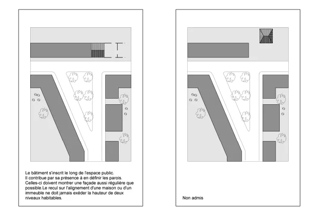 Excerpt from the Mons Municipal Urban Planning Guide regarding the siting of a new construction in public space.
You will most often find this document on the municipality’s website. It is the reference document for sketching out a real estate project.
Summary
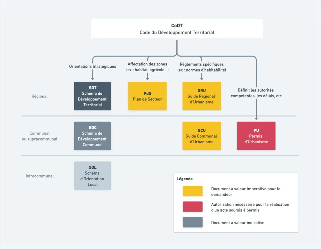 Spatial and Urban Planning tools in the Walloon Region.
In Wallonia, the Territorial Development Code governs Spatial and Urban Planning. This text sets general rules such as which acts require a permit, permit issuance deadlines, the competent authorities, and the planning tools.
Among these tools, the Schemes define the broad strategic directions, based on the issues of the relevant territory. These schemes exist at the regional, supra-municipal, municipal and sub-municipal levels. They are not binding for the applicant, but can influence the municipality’s decision on whether to grant an urban planning permit.
The Guides set out rules to be followed in urban planning matters. These include, for example, habitability standards (minimum floor area, ceiling height, etc.) or construction standards (geometry, distance from the road, facade alignment, etc.). There is a Regional Guide that applies throughout Wallonia, as well as Municipal Guides that apply locally and specify the local implementation of certain rules.
Finally, it is the municipality that is the competent authority for granting an urban planning permit. To do so, it reviews the file by analyzing the project’s compliance with the Sector Plan, regional (GRU) and local (GCU) standards, as well as its alignment with the strategic directions (SDT, SDC, SOL).